The Melrose Park Precinct spans approximately 55 hectares and is divided into Northern and Southern Growth Precincts, with Hope Street marking the boundary between the two. Planning for the area’s redevelopment began in 2016 and has involved extensive consultation between the Council, landowners, applicants, and various State agencies.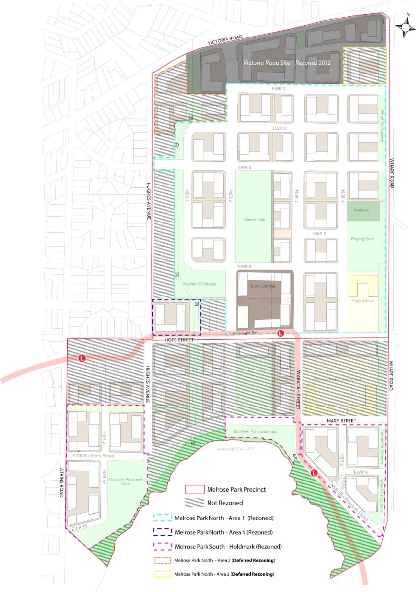
Planning Background
(Back to top)Over the years, land use needs in Sydney have evolved, rendering many existing industrial areas unsuitable for continued industrial operations. The Parramatta Employment Lands Strategy 2016, reviewed in 2020, identified a decline in Melrose Park due to the restructuring of the pharmaceutical manufacturing industry, which has been relocating operations offshore or to larger industrial parks.
The large, purpose-built warehouses in Melrose Park were difficult to repurpose, and factors such as distance from major transport corridors and proximity to residential areas made the precinct unsuitable for ongoing industrial use. Consequently, the Council designated the precinct for urban renewal.
Structure Plans
The Melrose Park Structure Plans guide the precinct’s urban renewal, ensuring a coordinated approach to redevelopment by the Council, landowners, and State agencies. These plans provide an overview of where density and supporting infrastructure should be located. Unlike a Planning Proposal, the Structure Plans do not rezone land or change any planning controls such as building heights and floor space ratios.
Transport Management & Accessibility Plan (TMAP)
The development within the Melrose Park precinct is supported by a Transport Management and Accessibility Plan (TMAP), endorsed by Transport for NSW (TfNSW). The TMAP is a required technical document for all Planning Proposals (rezonings) within the precinct, in addition to standard site-specific traffic and transport impact assessments.
The TMAP indicates that the precinct can accommodate up to 11,000 dwellings, provided the necessary infrastructure (such as the bridge to Wentworth Point) is delivered as outlined in the Implementation Plan. The required infrastructure will be funded through a combination of Local and State Planning Agreements and development contributions. Local Planning Agreements typically cover infrastructure that directly serves Melrose Park residents, such as open spaces and community centres, while State Planning Agreements include infrastructure for broader regional infrastructure, such as major road and school upgrades.
Development Status
(Back to top)The redevelopment of the Northern Precinct is more advanced than the Southern Precinct due to landowner arrangements. Approximately 85% of the land in the Northern Precinct is owned by developers Sekisui and Deicorp. In contrast, the major landowner in the Southern Precinct is Holdmark, which owns just under 50% of the land.
Rezonings
To facilitate redevelopment, a Planning Proposal is required to amend the Parramatta Local Environmental Plan (LEP) 2023. Section 8.2.6 of the Parramatta Development Control Plan 2023 applies to rezoned land in the Melrose Park precinct. The completed rezonings are shown below.
Its noted that the Melrose Park North rezonings for “Area 2” (15-19 Hughes Avenue & 655 Victoria Road) and “Area 3” (8 Wharf Road) have a deferred commencement date and are not currently in effect.