From Sunday, 25 May 2025, City of Parramatta’s Natural Areas team will begin a program of urgent repairs to the Hunts Creek Walking Track between Statham Avenue and Northam Drive, North Rocks. The walking track will be closed with detours in place.
For more information, please see Hunts Creek Walks and Tracks web page.
Walkability for liveability
Walkability is recognised as one of the key aspects that make a city liveable.
Parramatta has many great destinations, local centres and distinct heritage and cultural experiences that all make it a great place to walk and cycle.
The City of Parramatta recognises the importance of walkability for liveability and we are seeking to create a safe, comfortable and interesting City for people to get active and connected.
The strategy is a long-term plan that will provide a network of high quality walking routes through our streets, open space and river corridors. Through public exhibition and engagement our community provided strong feedback and support for the project, its targets and objectives.
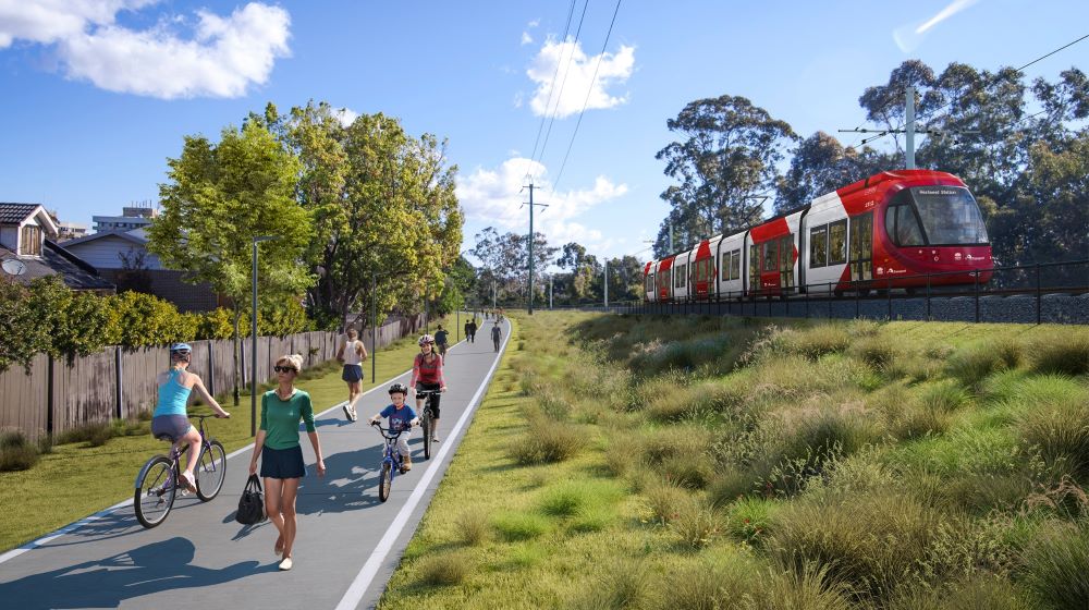
New Active Transport Link between Carlingford and Parramatta now open
A new walking and riding path, also known as an active transport link, has been delivered by Transport for New South Wales as part of the Parramatta Light Rail Stage 1 project.
The 5.7km path features multiple access points between Boundary Road in Carlingford and Tramway Avenue in Parramatta, as well as bike racks, seating, water stations, journey maps, signs, and motion-sensor LED lighting.
Learn more: visit our cycling page
Walking trails
(Back to top)Lake Parramatta Reserve
Lake Parramatta Reserve is a 75ha bushland reserve only two kilometres from the Parramatta CBD.
You can access the entrance to the reserve from Lackey Street off of Bourke Street, in North Parramatta.
A number of formal tracks form a circuit around the edge of the lake, which was Parramatta's original water supply.
The Ponds Walk
The Ponds Walk is a 6.6km track that follows Ponds/Subiaco Creek from Eric Mobbs Memorial Park in Carlingford to Jim Crowgey Reserve in Rydalmere.
Read more about this trail in the the Ponds Walk brochure
Terrys Creek Walk
Terrys Creek Walk is a 2km track in Eastwood/Epping that allows walkers to experience Blue Gum High Forest.
Read more about this trail in the Terrys Creek Walk brochure
Parramatta River Walk
There are three walking trails along the Parramatta River:
Governor Phillip Walk
Historic Houses Walk
Lake Parramatta Walk
Discover water views with the Parramatta River Walk
Ryde Bridge to James Ruse Drive map
James Ruse Drive to Lake Parramatta map
Great West Walk
The Great West Walk is a 65km walking route stretching from Parramatta Park to the foot of the Blue Mountains. The walk traverses a varied landscape of protected Cumberland Plain woodland, local river systems, public parklands, Australia’s oldest architecture, some of Western Sydney’s most iconic urban landscapes.
Find out more about the walk here.
Parramatta Ways Walking Strategy
(Back to top)The City of Parramatta endorsed the Parramatta Ways Walking Strategy aimed at improving walkability throughout the Parramatta Local Government Area and making people the priority in our streets.
The strategy is a long-term plan that will provide a network of high quality walking routes through our streets, open space and river corridors. Through public exhibition and engagement our community provided strong feedback and support for the project, its targets and objectives.
Other initiatives
(Back to top)Also complementing the Parramatta Ways Walking Strategy are other initiatives that will make our city more walking and cycle friendly, such as the:
Get in touch
If you have any questions you can get in touch with our Sustainable Transport Team at TransportPlanning@cityofparramatta.nsw.gov.au